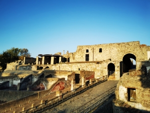
Until a few decades ago, it was thought that the first urban nucleus of Pompeii was much more limited than what is seen today. It was believed that the walls developed around the “Vicolo del Lupanare”, “Vicolo degli Augustali” and ” Vicolo dei Soprastanti ”, that is the area closest to the current Forum. This theory was also reinforced by the presence, in the aforementioned area, of a road network oriented in a different manner from the rest of the city. It was then thought that, later, around the fifth century BC, the city had developed towards the East and North. In other words, it was believed that, after an initial urbanistic phase where Pompeii developed over just 9.3 hectares,  it later spread to over 63.5 hectares. (SEE NOTE)

During his directorship of the excavations of Pompeii from 1982 to 1984, Stefano De Caro started a series of archaeological digs in the Vesuvian city, both in the northern sector of the fortification, near the Tower XI, and in the southern, in the section between Porta Nocera and the Tower IV.

Today, based on the archaeological results coming from those important excavation campaigns, it is believed that three different generations of city walls  were superimposed in the Vesuvian city over the centuries:


1. The first, and oldest, is in local tufa stone, the so-called “pappamonte”, and dates back to at least the 6th century. b.C. In this first phase the walls cover already roughly the same way as the current one, except for the north-eastern corner (where Porta di Nola would be built), where the path seems to have moved slightly towards the west. Their structure was very simple and consisted of a few rows of square blocks in “pappamonte”  or tender lava stone, above which an embankment (on the outer wall) no more than 3 meters high was set. A “pomoerium” lane ran along the inner edge of the city walls.


2. The second wall circuit consisted of two curtains of “Calcare del Sarno” (Limestone) and an inner core of ground wrought  with flakes of stone. The walls were in orthostates, ie, slabs placed vertically, but to allow better interlocking of the walls with the filling soil, rows of limestone blocks were arranged horizontally at regular distances, in order to be able to penetrate  the ground. These “pre-sannitic” walls of Pompeii reflect the typical characteristics of  Greek construction method, defined by archaeologists as “emplekton”, borrowing the term from Vitruvius who used it to define the inner core of the double curtain walls. This type of city walls, already extensively attested in the Greek “pòleis” (cities) of the Gulf of Naples (“Neapolis” and Cuma), seems to date back to the 4th century AD.


NOTE  = Eugenio La Rocca, Mariette e Arnold de Vos, Guida archeologica di Pompei, Arnoldo Mondadori Editore, 1976, pp. 12-13


Excerpt from:  Marco Fabbri, Difendersi, in Massimo Osanna e Carlo Rescigno, Pompei e i Greci, Electa, 2017, pp. 268-271
 

For further info about our guided tour of Pompeii


The second century B.C. is the “golden age” of Pompeii, a century in which profound transformations in urban planning, of the main places of worship and of the ways of living, were   recorded.

At this point in history, Puteoli became the main port of Rome and began to perform a function of “port-warehouse”, ie, of a large port with a multiplicity of piers and warehouses where the goods from all over the Mediterranean, especially the Eastern part , were unloaded and stored. From this great “port-warehouse”, redistribution took place on a regional scale, based on a hierarchically subordinate port system in which the “epineion” (emporium) of Pompeii played a central role. Through the course of the Sarno river, this dock redistributed the Mediterranean products to the more internal areas such as Nola, Nocera and Acerra. (1)

This progressive enrichment of Pompeii allowed important urban and architectural innovations in the Vesuvian city, innovations that linked Pompeii to the other allied cities of Rome. These breakthroughs were inspired by the new models of urbanization of “International Hellenism”, which Rome appropriated starting from the second century. B.C.

It is precisely in Samnite Pompeii that this phenomenon of progressive adaptation to the Hellenistic-Roman models developed, that is, in the period before Pompeii became a Sillan colony of 82 BC.

There are many monuments, both public and private, from the second century. B.C. that illustrate the development of the city of Pompeii and the adoption of the models of “International Hellenism”: monumentalization of the Forum, reorganization of the so-called  Triangular Forum, with the construction of the adjacent theater and campus/gymnasium, construction of the first thermal facilities, construction of large private houses with atrium and peristyle. The case of Pompeii is unique: a city timelessly preserved in its entirety, covered  with pumice stones and volcanic ash by the  Vesuvian eruption of 79 Ad.  The city clearly shows us how the process of enriching the urban landscape according to the canons of “International Hellenism” , already in practise in Sicily, also involved the Greek and Italic cities of Romanized Southern Italy. Naturally, in the peninsula the architectural models were filtered from Rome and adapted to both political-administrative and cultural needs of a society that was by now profoundly Romanized. Pompeii and the Campania region, in fact, reproduced some of the oldest examples of monumental building typologies that later, in the height of the imperial era, would be exported from Rome to the provinces, starting from Sicily: theaters, amphitheaters, baths, basilicas, aqueducts. (2)

In Pompeii, local patricians vied with those who came from Rome to practice the “otium” (SEE NOTE) in the maritime villas of Campania, in an “Asiatica luxuria” – this unbridled luxury that was inspired by the grandiose Macedonian courts – was made possible by the new riches of oriental origin. To this end, suburban villas, a new building type, arose, and the new architectural elements with  Greek names or in Greek style, such as the “peristyle”, “exedra”, “diaeta”, “triclinium” and “oecus”, were incorporated in the mansions in the city. .(3)

One of the most sumptuous examples of “domus” (House) built in Pompeii in the 2nd century AD. is the “House of the Faun” with its magnificent mosaic (more than one and a half million tesserae), which represents the decisive moment of the battle of Alexander the Great against Darius III of Persia at Issus, when the Persian king, in the moment of defeat, attempts to flee.

NOTE: This Latin term  had the idea of withdrawing from one’s daily business (negotium) or affairs to engage in activities that were considered to be artistically valuable or enlightening (i.e. speaking, writing, philosophy).


BIBLIOGRAFIA:

  1. Luana Toniolo  “Commerciare” –in Massimo Osanna e Carlo Rescigno, “Pompei e i Greci”, Electa 2017, pp. 231
  2.  Gioacchino Francesco La Torre – Sicilia e Magna Grecia – Editori Laterza 2011 – pag.243
  3. Eugenio La Rocca, Mariette e Arnold de Vos, Guida archeologica di Pompei, Arnoldo Mondadori Editore, 1976 pp. 33-34


For further info about our guided tour of Pompeii


Women played a very important role in Etruscan society.

Both the practice of Matronymic (a social norm according to which children took their mother’s name) and the participation of women in banquets, unlike the Greek symposia, show how important the woman in Etruscan society was. It also appears that simply having an Etruscan mother was sufficient to ensure a child Etruscan citizenship.

Working with wool was the symbol of women just as working with weapons was that of men. Educating was the destiny of the Etruscan woman, spinning  her emblem.

Moreover, from the end of the 9th century BC, some women also presented a pair of equine bits among their funerary objects: in the necropolis of Veio (Tuscany), for example, there was no substantial numerical difference between the tombs of males and females indicated as wagon holders. Probably the bits in the male graves could indicate war or hunting wagons and those in the female graves could allude to a carriage.

Those women were undoubtedly at the top of the various Villanovan social groups, perhaps the companions of the warrior-chiefs: After all, marriage, at least from the end of the 9th century BC, when relations with different communities within and outside the individual cultural areas are more evident, began to be  considered a means of creating bonds of solidarity or of alliance. Women, much the same as raw or processed materials, or like livestock, could be included in the exchange of gifts or repayments. Female attire was also generally richer than that of males and starting from the second half of the 9th century BC, sumptuous parures characterized certain tombs: the woman adorned with precious goods was herself a valuable asset to be exhibited in order to manifest the “status” of the family group.


Excerpt from:   Gilda Bartoloni, “La Cultura Villanoviana. All’inizio della storia etrusca”, Carocci Editore, Roma pag.187
 

For further info about our guided tour of Pompeii


In 1731 King Charles of Bourbon inherited the famous “Farnese collection” from his mother, Elisabetta Farnese. When the enlightened sovereign ascended the throne of Naples in 1734, he took these splendid works of art with him in dowry to the Parthenopean city. Charles furthermore ordered the excavations of Herculaneum (1738) and Pompeii (1748), which led to the discovery of an impressive number of Roman Art treasures.

However it was only in 1777 that Charles’s son, Ferdinand IV of Bourbon, determined by decree to gather these great dynastic collections, (Farnesian, Pompeian and Herculaneum) together in the  “Palazzo dei Vecchi Studi” (the Old University) and earmark them for public use. Moreover, this new building was envisaged as an encyclopedic museum where all human knowledge should be situated: works of art, books, papyri, studios  and even an astronomical observatory. Following the dominant Enlightenment culture, the educational aspect of this museum and its importance as a public utility were emphasized. Consequently,Ferdinand intended to bring together workshops, laboratories, painting, sculpture, and restoration schools and more. It was aimed to create a museum-workshop-school in the building. However, in order to do this, the old “Palazzo degli Studi” required profound changes and, in 1806 when the French arrived, the building was still under restoration.

During the French domination, first Giuseppe Bonaparte, and then Gioacchino Murat, abandoned the museum’s encyclopedic project for nearly 10 years, “reducing” it to a simple venue for the exposition of the imposing Farnese and Bourbon collections.

During  the Napoleonic period, all the leading museums in the territories conquered by the French armies were stripped of their most important masterpieces which were channelled  to the Louvre Museum in Paris. But the Archaeological Museum of Naples (like the Brera Museum in Milan) did not suffer from depletion; in fact it was enriched with famous masterpieces.

Murat sought an autonomous kingdom in Napoleonic Europe. The new director of the Museum, Michele Arditi (1807-1838), immediately showed his worth: first of all he introduced  more severe management of the personnel compared to the previous state of disorder; the obligation and control of daily working hours; respect for a precise work timetable and the prohibition of objects being taken out of the Museum. After the fall of  Murat (1815), during the Bourbon restoration, Ferdinand I again confirmed Michele Arditi as director of this institution which was growing continually.

What clearly made the difference between French and Bourbon management of the Archaeological Museum  was that, with his return, King Ferdinand I explicitly stated that the collections of the Archaeological Museum were his “allodial property” and therefore alienable. The royal sites belonged to the Crown – and were therefore not saleable, – but the collections were property of the king (and therefore privately owned). The idea advanced by the French kings, that artistic masterpieces were  protected by the State, was therefore denied by this declaration of Ferdinand I.

The restored Bourbon monarchy maintained  the original educational and public purpose of the Archaeological Museum of Naples, but at the same time it displayed a mentality not in line with the most modern Enlightenment principles.

Later, only in 1822, would the transfer of the archaeological artifacts from the “Herculaneum Museum” of Portici be completed, but despite all efforts, the Royal Bourbon Museum continued to seem  an overcrowded repository  without any precise exhibition criteria. Infact, the first extensive re-organization only took place during the Unification of Italy under the decisive intervention of Giuseppe Fiorelli.


Excerpt from:  Nadia Barrella e Ludovico Solima, Musei da svelare, Luciano editore, Napoli, 2011, pp. 17-23   

For further info about our guided tour of the National archaeological Museum of Naples


During the Bronze Age, particularly from the 16th century [from the Middle Bronze Age 1] to the 11th century BC [at the end of the Bronze Age], intense contacts between indigenous groups in Southern Italy and Sicily and the Mycenaeans are confirmed with certainty: this is confirmed by the discovery in modern times of ceramics and metal objects of Aegean production in numerous Italian proto-historic contexts, both inhabited and necropolitan.In the Western Mediterranean the Mycenaeans sought raw materials, especially metals, to satisfy the needs and consumption of the new Peloponnesian aristocracies. The first contacts are documented by ceramics found in the Phlegraean archipelago (Vivara) and in the Aeolian archipelago (Lipari and Filicudi) and, to a lesser extent, in Apulia (in the Gargano and Porto Perone near Taranto). In fact, their traditional route in the Western quadrant of the Mediterranean involved passing through the Strait of Messina and then touching the Aeolian islands before heading into the Gulf of Naples.

However,  the greater intensity of the contacts was established in the fourteenth and thirteenth centuries B.C., when the dominion of the Mycenaean kingdoms also extended to Crete.  Ceramics of that period have been found in various areas of the Peninsula and Sicily (especially in the Brindisi area, the Gulf of Taranto, the Ionian Calabria, the Aeolian islands, Ustica, in the area of Syracuse, the area of Agrigento) and even beyond (Sardinia and the Iberian peninsula). However at that historical moment the process was not managed by the Mycenaean centers of the Peloponnese alone, but also involved the islands of Crete, Rhodes and Cyprus. Therefore, at that time, next to the traditional Tyrrhenian route, the Mycenaeans added another, more Southern one, which connected the ports of the Levant (located in Lebanon, Cyprus, Rhodes, along the southern coasts of Crete) with Eastern and Southern Sicily and Southern Sardinia through the intermediate ports of the Nile delta, the coasts of Libya, Malta and Pantelleria. From the 13th century onwards in the most strategic points of these routes, important emporiums were founded by the Mycenaeans, in the past erroneously interpreted as real Mycenaean settlements, almost as  “ante litteram” (primitive) colonies.The collapse of the Mycenaean civilization, between the end of the XIII and the beginning of the XII centuries, caused a slowdown in relations between East and West. In the XI century B.C., as a result of social upheavals and movements of populations involving the Greek continent (the coming of the Dorians), imports ceased altogether and there began, both in the Aegean world and in the Italian peninsula and in Sicily, a long phase of closure. The Phoenicians would inherit from the Mycenaeans of Rhodes and Cyprus a  wealth of knowledge regarding  the resources and moorings of the distant West and about the routes to reach it.

In the late Bronze Age, contacts with the Aegean world modified the indigenous societies of Southern Italy and Sicily, which began to show a hierarchization and concentration of the inhabited areas, the appearance of huts and emerging tombs and of buildings specialized for the storage of foodstuffs, the provision of large quantities of metal, the emergence of specialized artisans (potters and metal workers) and the strengthening of trade and commerce. This would lead to the start of a social stratification process that involved the main areas of Southern Italy and Sicily, which, presented up to the 14th century BC. ( Middle Bronze Age 3) were largely undifferentiated socially. However, between the recent Bronze Age (13th-12th century BC) and the Final Bronze Age (11th-10th century BC) small territorial entities were assimilated into  the simple “chiefdoms”, a model elaborated by Anglo-Saxon archeology, to define communities led by chiefs. These communities were of the order of a few thousand inhabitants, already of a tendentially “proto-urban” nature. However, at this historical point,  the Mycenaean Kingdoms, which were complex “chiefdoms”, cannot be assigned this model, given the lack of princely burials, residences of royal rank and a far more articulated political organization in which the use of writing cannot be disregarded.


Excerpt from Gioacchino Francesco La Torre, Sicilia e Magna Grecia, Editori Laterza, 2011,   pp 12-16
For further info about our guided tours of Pompeii


As we have seen, the empire of Sybaris went beyond the borders of the area directly marked by the sanctuaries. The foundation of Poseidonia made the Sybaris’ aims explicit to open a door on the Tyrrhenian Sea as close as possible to the flourishing Etruscan settlements of Campania, located just north of the Sele river, and at the same time, to control the communities of Oenotrians of the interior who, between the eighth and sixth centuries B.C. were able to consolidate and to take on the role of attractive business partners. These were small inhabited areas that were in close contact with Sybaris from whom they learnt the use of writing and the alphabet, as shown by the inscription on the “Castelluccio” olla-shaped jar and, above all, the “Tortora cippus”. It is a kind of “lex sacra” (sacred law) written in a palaeo-Italic language (the language of the Oenotrians), adapting and integrating the Achaean alphabet used by Sybaris and Poseidonia.
The same Oenotrian communities used a certain coinage named by the modern scholars the “coins of the alliance”. They were incuse coins (with hollow images), probably beaten at Sybaris, which presented on one side the retrospective bull (which looks backwards) and on the other side the names of the towns such as PAL-MOL (Palinuro and the nearby Molpa), SIRINO-PYXOES (Sirinos in the “Valle del Noce” and Pixunte in the Gulf of Policastro).
For the maintenance of this complex political-institutional organisation, Poseidonia played a very important role. That Sybarite colony represented the last bastion of Achaean Hellenism in front of the flourishing Etruscan centres north of the Sele river and privileged mediator with the communities of Oenotrians gravitating on the Tyrrhenian Sea. This role was reiterated on the occasion of the foundation of Velia (Herodotus, I, 167) – Poseidonia favoured the foundation of Velia by the Phocaeans – but also in the Olympia treaty where Poseidonia together with the Gods, was called to guarantee the pact between Sybarites and the Serdàioi.
But the great power of Sybaris did not hold up to the innovative thrusts that rose from the great mass of the lower-middle social classes, kept away from the many riches. Towards the end of the 6th century, B.C. riots led to the rise of the tyranny of “Telis”, who was so strongly anti-aristocratic that in 510 B.C. 500 Sybarite nobles were forced to find shelter in the oligarchic Kroton, asking and obtaining asylum. When Telis asked for them to be returned, Kroton – where a strongly influential figure was Pythagoras – refused. The result was a war that saw Sybaris badly defeated. After a siege of 70 days, the city itself was destroyed forever by the diversion of the Crathis (Crati) river which submerged the remains (Strabo, VI, C 263). In this regard, Domenico Mussi, an Italian historian (1934-2010), has rightly pointed out that this war was not a simple fight between neighbouring Greek “pòleis” (cities), but two “pòleis” with opposite political and institutional orientations.
The outcome of the war profoundly changed the political scenario of “Magna Graecia”, and radically changed the previous balance, weakening the Achaean cities. The indigenous populations economically and/or politically linked to Sybaris went through a critical period, as can be seen from the downsizing of many main centres and their necropolises and the end of the emissions of the “coins of the alliance”.

Excerpt from: Gioacchino Francesco La Torre, Sicilia e Magna Grecia , Editori Laterza, 2011, pp 84-90


For further info about our guided tours of Pompeii and Herculaneum


The colonisation process of Southern Italy and Sicily lasted a couple of centuries and began in the 8th century B.C.

The first Achaean colony seems to have been Sybaris, in the middle of an alluvial plain between the mouths of the Crathis (Crati) river and the Coscìle river, the ancient Sybaris. According to Ephorus of Cyme, a Greek historian – c.  400 – 330 B.C. this Achaean city lived for 210 years and was destroyed in 510 B.C. by Kroton.  It can thus be traced back to 720 B.C. for its foundation. Strabo (VI, C 263) reports that oikistes (see Note) of Sybaris was Is who was a native of Elice, unknown city of Achaea in Greece.

The innumerable studies carried out on the proto-historic centres in the area of Sybaris, confirm that the arrival of the Achaeans in that territory and the subsequent foundation of Sybaris represented a strong impact on the indigenous villages.  All the centers of the early Iron Age (IX-VIII centuries B.C.) were destroyed and abandoned at the end of the 8th century B.C.   But as it happened for Syracuse, very probably Sybaris also did not exterminate the indigenous populations that inhabited the district. Many of them were probably enslaved or at least used as labour in the countryside and in the cities.

The Achaean “pòlis” (town) soon succeeded in creating a real empire, its merchants ascended along the rivers that flow into the Ionic Sea, they reached the central Apennine mountains and from there they descended along the rivers flowing into the Tyrrhenian Sea. They created a district totally controlled by Sybaris. Strabo (VI, C 263) described Sybaris as a real “empire” that in the Archaic period (600 B.C. – 480 B.C.), controlled 4 populations and 25 cities.

To understand the precocious territorial growth of this Achaean pòlis (town), it is interesting to consider also what Diodorus reported (XII, 9, 2): he wrote that Sybaris granted its citizenship to foreigners with relative ease.

This vast empire of Sybaris was articulated internally through different gradation, ranging from the direct control of the chòra politikè (territory outside the walls where farmers cultivated the fields and dedicated themselves to agriculture), to formally equal relations with some of the more distant communities. An important inscription found at Olympia, datable to the second half of the 6th century. B.C. preserves elements of fundamental importance that integrate the Strabo’s description. This is a peace treaty signed between Sybaris and their allies (Sýmmachoi) and the Serdàioi, an indigenous community that recent studies tend to place in the “Valle del Noce”, on the border between northern Tyrrhenian Calabria and Lucania. Ultimately the empire of Sybaris, beyond the original chòra, where indigenous people most probably worked as slaves, consisted of a substantial group of subdued communities (probably 4 populations and 25 cities, as Strabo says) and finally in a circle of allies (the Sýmmachoi of the  Olympia treaty), at least formally independent. In the Greek colonial world, this is probably the first example of a complex territorial entity, extended beyond the limited boundaries of traditional pòlis.

Very important were also the extra-urban sanctuaries of Sybaris, real projections of the city in the “chòra”. Through the sacred dimension, they marked the progressive control of this Achaean “pòlis” (town) on the territory and, at the same time, attracted the indigenous populations of the district, also assuming the role of privileged places of contact and exchange in the border areas. Since the time of the foundation, the sacred marked the limits of the “chòra” of Sybaris.        NOTE: The individual chosen by an ancient Greek polis (town) as the leader of any new colonisation.

 Excerpt from: Gioacchino Francesco La Torre, Sicilia e Magna Grecia , Editori Laterza, 2011, pp 84-90


For further info about our guided tours of Pompeii and Herculaneum


The perimeter of the city walls of Pompeii is 3220 m and has seven recognized gates; of an eighth – Capua Gate – it was assumed the existence based on a possible symmetry in the position of the gates. (1) Like any city in the ancient world, the walls of Pompeii were of particular importance because, in addition to performing a defensive function, they also marked the passage between the urbs (city) and the ager (countryside), between citizens and those who were not yet citizens (the indigenous rural population, for example) or those who were no longer (the deceased). The city walls were impassable because they were untouchable in the religious and legal sense of the term. The jurist Gaius, active between the reign of Hadrian and that of Marcus Aurelius (2nd century AD), used the term “res sanctae” (sacred property) to indicate the walls and their gates. (2) To justify and legitimately base the appropriation of a space which was completely removed from the domain of Nature, a divine origin sanctioned in its own settlement with its walls in order to directly involve the Gods in the fate of the city. (3) In Greek times in many cases – in Magna Graecia we know the cases of Locri and Agrigento – the sacred areas were located along the route of the city walls, both internally and externally, to constitute the best known cases of “ceinture sacrée” (sacred city walls), according to a lucky definition by François de Polignac. In practice, the whole city was physically placed under the protection of the Olympian Gods, through a widespread distribution of sacred areas along the perimeter of the city walls, above all at the gates. (4)

It is surprising how this description of “ceinture sacrée” can be perfectly found even in Pompeii. In fact, with the exception of the “Capitolium”, obviously located in the Forum, all the main sacred sanctuaries (Temple of Apollo, the Triangular Forum, Temple of Aesculapius or Jupiter Meilichios, the Temple of Venus) lie by two of the seven city gates, the so-called “Marina Gate” and “Stabian Gate”.

Furthermore, city gates marked a border that was often demarcated not only by physical defenses (towers, ditches, gates), but also by symbols that evoked a magical protection of urban space (sacred images, apotropaic symbols) (5). Interesting in this regard is what was found, for example, in the niche at the main archway of Porta Marina in Pompeii: a fictile statue of Minerva, guardian goddess of the city gates. (6)

For what concerns the first urban nucleus of Pompeii, until a few decades ago, it was thought that it was much more limited and its walls developed around the “Vicolo del Lupanare”, “Vicolo degli Augustali” and ” Vicolo dei Soprastanti ”, which is the closest territory to the current Forum. This theory was also reinforced by the presence, in the aforementioned area, by urban planning oriented in a different way from the rest of the city. It was then thought that, later, around the fifth century BC, the city had developed towards the East and North. In other words, it was believed that, after an initial urbanistic phase where Pompeii developed to just 9.3 hectares, it later developed to 63.5 hectares. (7)

To crown the aforementioned theory, in 1979 the German scholar Hans Eschebach published an authoritative monograph, which stated that in the 6th century BC, where today the “Stabian Baths” rise, the fortifications ran with a moat and a city gate. (8)


BIBLIOGRAPHY:

  1. Eugenio La Rocca, Mariette e Arnold de Vos, Guida archeologica di Pompei, Arnoldo Mondadori Editore, 1976, pp. 85
    2.  P. Gros, L’architettura romana dagli inizi dal III secolo a.C. alla fine dell’Alto Impero: i monumenti pubblici, Milano, Longanesi & C. 2001, pag 28
    3.  Giuseppe Gisotti, La Fondazione delle città, Carocci Editore, 2016, pp. 17-18
    4.  Gioacchino Francesco La Torre, Sicilia e Magna Grecia, Editori Laterza, 2011, pag.299
    5.  Giuseppe Gisotti, op. cit. pag. 18
    6.  Fabrizio Pesando, Maria Paola Guidobaldi, Pompei, Oplontis, Ercolano, Stabiae, Guide Archeologiche Laterza, Bari, 2018, pag. 31
    7.  Eugenio La Rocca, Mariette e Arnold de Vos, op. cit., pp .12-13
    8. Monika Trümper, Curare se stessi, in Massimo Osanna e Carlo Rescigno, Pompei e i Greci, Electa, 2017, pag. 265


For further info about our guided tours of Pompeii and Herculaneum


Wine was the most widespread drink and certainly the most loved by the Romans in their daily diet and an important element of convivial moments. The Romans had compiled real classifications of the finest wines, among which Falerno excelled, but Surrentinum and  Vesbius or Vesuvinum also enjoyed a good reputation. Particularly appreciated wines were also those produced in Greece and in the Aegean islands, for example the lyttios, greatly appreciated by the Pompeians, as shown by the amphorae of particular shapes found and the inscriptions read on them. The wine was never drunk pure, but generally served with water, hot or cold depending on the season. Furthermore, liqueur wines such as mulsum -the best mulsum was obtained from the must -, passum and defrutum were produced. Defrutum was a condiment based on reduced must used by cooks of ancient Rome; together with garum it was one of the most used sauces in the preparation of all sorts of dishes. Poor drinks were lora, obtained from maceration in water of the pressed marc (vinacce) and  posca, a drink of water and vinegar.

From the wine sold in Pompeian thermopolia (wine bars) we also know the cost, reported by the inscription CIL IV 1679: “Hedoné proclaims: Here we drink for only one axis; with two you will drink better wine; with four you’ll drink Falerno ”. (1)

Most of the wine consumed in the cities was made locally. At least forty local farms and estates had cellae vinariae or wineries, some producing on an enormous scale. These estates are characterized by a large number of dolia (large earthenware vase), buried up to the rim (defossa), in which the wine was stored as it matured. “Villa Regina” at Boscoreale had eighteen of these. Some were for olives and grain, but the vast majority contained wine. Many of them were still capped with terracotta lids and sealed with mortar, showing they were full when the eruption happened. The wine remained in dolia until the following year, when it was sold or taken to the owner’s house in the city. The transportation of large quantities of wine required considerable effort, as each dolium could hold over twenty amphoras’ worth (about 120 gallons or 545 litres). In Pompeii, in front of the Forum Thermal Baths, we have also found a thermopolium where on one of its dolia (large jars), used for fermenting wine, the name “A Apulei Hilarionis” (“of A. Apuleius Hilarion”) was stamped.

Amphorae often carried a painted inscription. Some were basic, like those on the amphorae from Villa della Pisanella marked RUBR(um) = rubrum, the Latin for “red”. Others served as address labels. A fragment of an amphora from Pompeii bears the words, “For Albucia Tyche at Pompeii”, suggesting Albucia was a landlady. (2)


BIBLIOGRAPHY:

  1. Grete Stefani, Michele Borgongino, Cibus. L’alimentazione degli antichi romani. Le testimonianze dell’area vesuviana in AAVV Cibi e Sapori a Pompei e Dintorni , Soprintendenza Archeologica di Pompei, Edizioni Flavius,  2005, pp. 77-78
  2. Paul Roberts, Life and death in Pompeii and Herculaneum, The British Museum Press, 2013, pp. 66-68

For further info about our guided tours of Pompeii and Herculaneum

The Greek  Sanctuaries can be:

  1. a) Intramural
  2. b) Periurban
  3. c) Extraurban


Their location was linked to methods and needs that varied from city to city and that underwent evolution over time.


Urban and Periurban Sanctuaries:


They were preferably located on the “Acropolis”, citadel built on a high hill, but also in the same “agorài” (main squares), and then along the line of fortifications, to define a sort of “sacred belt”, or, in the case of coastal cities, at the mouth of the rivers, near ports and landings.


Extraurban Sanctuaries:


The “pòlis”, from the moment of its establishment in a foreign land, in addition to carving out a large urban space clearly oversized for the needs of the first comers, subtracted from the natives and also annexed a portion of territory outside the city. This space, functional to finding food resources, was the “chòra politikè”, an essential part, together with the city, of the “polis” political institution. Therefore, exactly as in the mother country, from the beginning the colonial “pòlis” was composed of an inseparable unity between the city (àstu) and that portion of the territory directly subjected to the government of the city (chòra politiké), dotted with sanctuaries from the earliest phase and variously articulated over timeSince the first generations,  the main extra-urban sanctuaries were almost never more than 10-12 km away from the city: it suggests that the size of the most ancient “chòra” allowed farmers however to reach their property (in the “chòra politiké”), to work the land and to return in city ​​over the same day.


Chòra Politiké:


It is clear how the best portion of the “chòra” was divided and assigned to the colonists according to a very well regulated property regime, of which we also have extraordinary testimonies of an economic-juridical or cadastral nature, although much later – the Tables of Eraclea (1), the Tables of the Sanctuary of Zeus Olympios of Locri or the Alesina Table. It is equally clear how at the edge of the divided and assigned countryside there was the “eschatià”, that is a sort of no-man’s land set against the indigenous territories or a neighbouring “pòlis”.

It is important to underline that the limits of the colonial territories towards the wooded areas of the “eschatià” and those inhabited by the indigenous populations were not well defined. Along the coast, on the other hand, especially in the case of (A remove) direct proximity between two neighbouring “pòleis”, the borders had to be established more strictly, so that the historical sources refer to border conflicts, trespassing and raids in the enemy territory, similarly to as documented for the motherland. In these cases the borders were often marked by natural elements, especially rivers, also sometimes marked by the sacred.

The sacred mediated between the Greeks and the indigenous communities of the hinterland, in those very permeable areas, defined as frontiers, in which the meeting of the different cultures became more fruitful and where the interests of the indigenous aristocracies were united with those of the dominant classes of the colonial “pòleis”.


Excerpt  from:  Giocacchino Francesco La Torre, Sicilia e Magna Grecia, Editori Laterza, 2011, pp. 157-160


For further info about our guided tours of Pompeii and Herculaneum